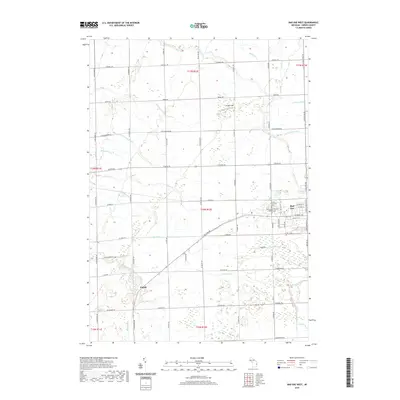
2019 Map of Bad Axe West
USGS Topo · Published 2019About this map
The western outskirts of Bad Axe and the surrounding agricultural landscape of Huron County dominate this 2019 survey. The terrain is defined by an intricate network of managed water systems, including the Pinnebog River, Bad Axe Cr, and numerous named agricultural channels such as Symons Drain and McMullen Drain. These features highlight the intensive land management required for the region’s farming economy. Near the city limits, the Colfax Township Cem and Sacred Heart Roman Catholic Cem provide significant landmarks for local genealogical research.
Find a feature on this map
68 named features on this map. Tap any name to fly to it.
Don’t see what you’re looking for? This feature index may not catch every label — zoom into the map to look around manually.
Map Details
Editions of this 2019 Bad Axe West Map
This is the sole edition of this map. No revisions or reprints were ever made.
Other maps of this area

1954 · Flint
USGS Topo · 1:250,000

1958 · Flint
USGS Topo · 1:250,000

1963 · New Greenleaf
USGS Topo · 1:24,000

1963 · Ubly
USGS Topo · 1:24,000

1963 · Gagetown
USGS Topo · 1:24,000
1970 · Rush Lake
USGS Topo · 1:24,000

1970 · Kinde East
USGS Topo · 1:24,000

1970 · Kinde West
USGS Topo · 1:24,000

1970 · Bad Axe West
USGS Topo · 1:24,000
1970 · Elkton
USGS Topo · 1:24,000