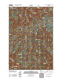
2011 Map of Bagby Hot Springs
USGS Topo · Published 2011About this map
Bagby Hot Springs serves as the focal point for this drainage network in Clackamas County, situated where Peggy Creek meets the Hot Springs Fork of the Collawash River. The 2011 survey details a landscape defined by steep drainages and prominent volcanic peaks, including Thunder Mountain and Baty Butte. This modern topographic study reveals a complex system of forest service roads providing access to the Skookum Lake Campground and the marshy expanses of Lost Creek Meadow. Moving south from Skookum Lake, the terrain falls away toward Pegleg Falls, while numerous tributaries such as Nohorn Creek, Hugh Creek, and Whetstone Creek carve through the heavily wooded slopes. The map provides a precise record of the hydrological environment before major wildfires impacted the region, preserving the exact layout of trails and access points to secluded spots like Joyce Lake and various smaller creeks.
Find a feature on this map
30 named features on this map. Tap any name to fly to it.
Don’t see what you’re looking for? This feature index may not catch every label — zoom into the map to look around manually.
Map Details
Editions of this 2011 Bagby Hot Springs Map
This is the sole edition of this map. No revisions or reprints were ever made.
Other maps of this area

1916 · Estacada
USGS Topo · 1:125,000

1929 · Mill City
USGS Topo · 1:125,000

1948 · Vancouver
USGS Topo · 1:250,000

1950 · Vancouver
USGS Topo · 1:250,000

1950 · Vancouver
USGS Topo · 1:250,000

1953 · Salem
USGS Topo · 1:250,000

1954 · Salem
USGS Topo · 1:250,000

1955 · Colton
USGS Topo · 1:62,500

1955 · Mill City
USGS Topo · 1:62,500

1956 · Fish Creek Mtn
USGS Topo · 1:62,500