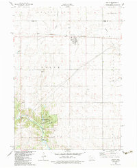
1982 Map of Bagley
USGS Topo · Published 1983About this map
Bagley serves as the primary rail-connected hub in this early 1980s landscape, situated along the Chicago and North Western tracks at the junction of Greene and Guthrie counties. The northern half of the region is defined by organized agriculture and the winding path of Mosquito Creek, while the southwest corner transitions into the recreation-focused valley of the Middle Raccoon River. This lower corridor includes the northern reaches of Lake Panorama and the dense woodlands of Springbrook State Park. Local history and genealogy are preserved at the Dodge Center Cem and Moffit Grove Cem, which reflect the early rural settlement patterns of Dodge and Victory townships. Functional landmarks like a Flowing Well and a Sandpit illustrate the area's geological and industrial utility during this era.
Find a feature on this map
24 named features on this map. Tap any name to fly to it.
Don’t see what you’re looking for? This feature index may not catch every label — zoom into the map to look around manually.
Map Details
Editions of this 1982 Bagley Map
This is the sole edition of this map. No revisions or reprints were ever made.
Other maps of this area

1952 · Panora
USGS Topo · 1:62,500

1954 · Bagley
USGS Topo · 1:62,500

1954 · Omaha
USGS Topo · 1:250,000

1957 · Omaha
USGS Topo · 1:250,000

1958 · Omaha
USGS Topo · 1:250,000

1971 · Coon Rapids NE
USGS Topo · 1:24,000

1971 · Bayard
USGS Topo · 1:24,000

1971 · Guthrie Center West
USGS Topo · 1:24,000

1982 · Guthrie Center East
USGS Topo · 1:24,000

1982 · Panora
USGS Topo · 1:24,000