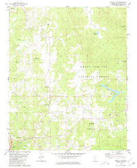
1980 Map of Bagley Lake
USGS Topo · Published 1981About this map
The hills and creek bottoms of Lafayette County are prominently featured in this 1980 survey, where the wooded expanses of the Holly Springs National Forest meet a network of small rural communities and family landmarks. The map documents a landscape defined by its drainages, including Graham Mill Creek, Hurricane Creek, and the headwaters of Puskus Creek, which support specialized activities such as the Fish Hatcheries near Bay Springs Br. Cultural history is well-preserved through numerous rural churches and burial grounds like Smiths Chapel Cem, St Peters Ch Cem, and the Oak Grove Memorial Gardens. From the edges of Abbeville in the northwest to the vicinity of Oxford in the southwest, the map traces the early 1980s transition from small agricultural settlements like McLarty and Cambridge toward more modern institutional land uses like Camp Hopewell.
Find a feature on this map
31 named features on this map. Tap any name to fly to it.
Don’t see what you’re looking for? This feature index may not catch every label — zoom into the map to look around manually.
Map Details
Editions of this 1980 Bagley Lake Map
This is the sole edition of this map. No revisions or reprints were ever made.
Other maps of this area

1940 · Oxford
USGS Topo · 1:62,500

1942 · Denmark
USGS Topo · 1:62,500

1943 · Denmark
USGS Topo · 1:62,500

1943 · Oxford
USGS Topo · 1:62,500

1944 · Tyro
USGS Topo · 1:62,500

1944 · Potts Camp
USGS Topo · 1:62,500

1945 · Potts Camp
USGS Topo · 1:62,500

1956 · Tupelo
USGS Topo · 1:250,000

1958 · Tupelo
USGS Topo · 1:250,000

1971 · Laws Hill
USGS Topo · 1:24,000