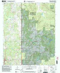
2000 Map of Bagley Lake
USGS Topo · Published 2003About this map
The northern reaches of Oxford and the rural outskirts of Abbeville define this landscape in north-central Mississippi at the close of the 20th century. Large sections of the terrain are dedicated to the Holly Springs National Forest and the Tallahatchie Experimental Forest, creating a mosaic of managed woodland and research areas. The map reveals a deeply rooted community infrastructure, evidenced by numerous country churches such as Jefferson Chapel and Philadelphia Missionary Ch, alongside family and community burial grounds including Owens Cem and Oak Grove Memorial Gardens.
Find a feature on this map
30 named features on this map. Tap any name to fly to it.
Don’t see what you’re looking for? This feature index may not catch every label — zoom into the map to look around manually.
Map Details
Editions of this 2000 Bagley Lake Map
This is the sole edition of this map. No revisions or reprints were ever made.
Other maps of this area

1940 · Oxford
USGS Topo · 1:62,500

1942 · Denmark
USGS Topo · 1:62,500

1943 · Denmark
USGS Topo · 1:62,500

1943 · Oxford
USGS Topo · 1:62,500

1944 · Tyro
USGS Topo · 1:62,500

1944 · Potts Camp
USGS Topo · 1:62,500

1945 · Potts Camp
USGS Topo · 1:62,500

1956 · Tupelo
USGS Topo · 1:250,000

1958 · Tupelo
USGS Topo · 1:250,000

1971 · Laws Hill
USGS Topo · 1:24,000