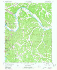
1959 Map of Bagnell
USGS Topo · Published 1981About this map
The Bagnell Dam anchors this landscape, marking the pivotal infrastructure that created the Lake of the Ozarks. This 1959-era survey shows the sprawling shoreline of the reservoir as it winds through the Osage River valley, contrasting the industrialized energy production at the dam with the growing recreational and residential areas of Osage Beach and Kaiser. Further inland, the map preserves the older, rural character of Miller and Camden counties through numerous family-named hollows and cemeteries, such as Fitzgerald Cem and Brockman Cem. The terrain is defined by the sinuous Osage River and its major bends, including Wilcox Bend, alongside established landmarks like the Grandglaize Fish Hatchery and Harmony Ch. The inclusion of a Landing Strip and Trailer Park reflect the mid-century transition toward a more tourism-focused economy around the lake.
Find a feature on this map
57 named features on this map. Tap any name to fly to it.
Don’t see what you’re looking for? This feature index may not catch every label — zoom into the map to look around manually.
Map Details
Editions of this 1959 Bagnell Map
3 editions found
Other maps of this area

1888 · Versailles
USGS Topo · 1:125,000

1888 · Tuscumbia
USGS Topo · 1:125,000

1893 · Versailles
USGS Topo · 1:125,000

1894 · Tuscumbia
USGS Topo · 1:125,000

1904 · Eldon
USGS Topo · 1:62,500

1932 · Versailles No 4
USGS Topo · 1:48,000

1933 · Iberia
USGS Topo · 1:62,500

1934 · Camdenton
USGS Topo · 1:24,000

1934 · Toronto
USGS Topo · 1:24,000

1934 · Lake Ozark
USGS Topo · 1:24,000