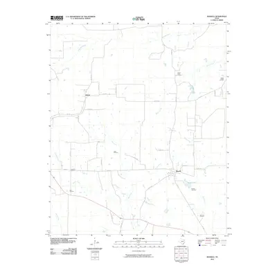
2010 Map of Bagwell
USGS Topo · Published 2010About this map
Bagwell serves as the central hub of this Red River County survey, where local life is oriented around a network of Farm to Market roads and small rural communities like Midway and Bluff. The landscape is defined by the winding paths of Denwiddie Bayou and several creeks that drain toward the south and east. Numerous family and community burial grounds, including Ward Cemetery, Dean Cemetery, and Youngs Chapel Cemetery, are scattered across the terrain, offering significant points of interest for genealogical research in this part of East Texas. To the southeast, the geography is marked by Brooks Lake and the Brooks Lake Dam, highlighting the local water management and recreation patterns of the early 21st century. The map provides a clear look at the intersection of agriculture and woodland that characterizes this region.
Find a feature on this map
41 named features on this map. Tap any name to fly to it.
Don’t see what you’re looking for? This feature index may not catch every label — zoom into the map to look around manually.
Map Details
Editions of this 2010 Bagwell Map
This is the sole edition of this map. No revisions or reprints were ever made.
Other maps of this area

1951 · Negley
USGS Topo · 1:24,000

1951 · Woodland
USGS Topo · 1:24,000

1951 · Manchester
USGS Topo · 1:24,000

1953 · Texarkana
USGS Topo · 1:250,000

1956 · Texarkana
USGS Topo · 1:250,000

1964 · Detroit
USGS Topo · 1:24,000

1964 · Deport
USGS Topo · 1:24,000

1964 · Bagwell
USGS Topo · 1:24,000
1964 · Dimple
USGS Topo · 1:24,000
1964 · Line Branch
USGS Topo · 1:24,000