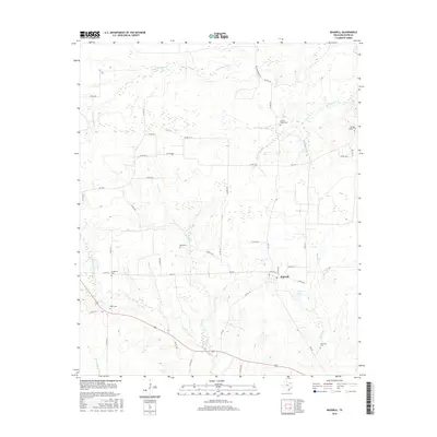
2016 Map of Bagwell
USGS Topo · Published 2016About this map
Bagwell serves as the central hub for this portion of Red River County, situated within a landscape defined by an intricate network of drainage systems. The northern reaches are dominated by the winding course of Denwiddie Bayou, while the southern terrain is carved by Scatter Cr, Coal Cr, and Ward Cr. This 2016 survey documents the enduring presence of family and community history through its numerous burial grounds, including the Blanton Creek Cem and Youngs Chapel Cem in the northeast. The rural character is preserved through a grid of county roads such as Co RD 2170 and Co RD 2111, which connect isolated homesteads to the primary thoroughfares of FM 2573 and FM 2120. Researchers will find a clear record of the local topography and hydrology, from the banks of Brooks Lake to the various unnamed wetlands that dot the bottomlands.
Find a feature on this map
50 named features on this map. Tap any name to fly to it.
Don’t see what you’re looking for? This feature index may not catch every label — zoom into the map to look around manually.
Map Details
Editions of this 2016 Bagwell Map
This is the sole edition of this map. No revisions or reprints were ever made.
Other maps of this area

1951 · Negley
USGS Topo · 1:24,000

1951 · Woodland
USGS Topo · 1:24,000

1951 · Manchester
USGS Topo · 1:24,000

1953 · Texarkana
USGS Topo · 1:250,000

1956 · Texarkana
USGS Topo · 1:250,000

1964 · Detroit
USGS Topo · 1:24,000

1964 · Deport
USGS Topo · 1:24,000

1964 · Bagwell
USGS Topo · 1:24,000
1964 · Dimple
USGS Topo · 1:24,000
1964 · Line Branch
USGS Topo · 1:24,000