
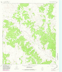
1964 Map of Bailey Draw
USGS Topo · Published 1966About this map
The West Texas ranchlands along the Crockett Co Schleicher Co boundary are defined by the winding paths of Bailey Draw and Buckhorn Draw. In the mid-1960s, this landscape was characterized by isolated homesteads and the emerging infrastructure of the energy industry. Ranching operations such as the Willoughby Ranch and Baugh Ranch anchored the rural economy, while several Oil Wells and a network of Pipelines indicate the intensifying subterranean resource extraction common to this part of the Edwards Plateau. A private Landing Strip near the Willoughby property highlights the vast distances between neighbors and the necessity of aerial transport for large-scale operations. The topography is meticulously mapped with ten-foot contour intervals, revealing the subtle drainages and ridges that dictated the placement of early ranch roads and Gravel Pits used for local maintenance.
Find a feature on this map
15 named features on this map. Tap any name to fly to it.
Don’t see what you’re looking for? This feature index may not catch every label — zoom into the map to look around manually.
Map Details
Editions of this 1964 Bailey Draw Map
2 editions found
Other maps of this area

1954 · Sonora
USGS Topo · 1:250,000

1958 · Sonora
USGS Topo · 1:250,000

1964 · Oglesby Ranch
USGS Topo · 1:24,000

1964 · Coupe Ranch
USGS Topo · 1:24,000

1964 · Moore Ranch
USGS Topo · 1:24,000

1967 · Nolen Draw
USGS Topo · 1:24,000

1967 · Savell Ranch
USGS Topo · 1:24,000

1967 · Double Mill Draw SE
USGS Topo · 1:24,000

1967 · Crockett Heights
USGS Topo · 1:24,000
1967 · Double Mill Draw NE
USGS Topo · 1:24,000