
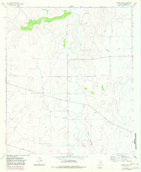
1964 Map of Moore Ranch
USGS Topo · Published 1966About this map
The high plateau of Schleicher County, Texas, is defined by its deep draws and ranching heritage as it appeared in the mid-1960s. Linthicum Ranch and Moore Ranch anchor a landscape where water is scarce, marked primarily by numerous scattered Wells and intermittent drainages like Dove Creek Draw and Granger Draw. The economic infrastructure of the era is evident through the extensive network of pipelines and the Eldorado Pumping Station, reflecting the importance of the local oil and gas industry alongside traditional cattle raising.
Find a feature on this map
16 named features on this map. Tap any name to fly to it.
Don’t see what you’re looking for? This feature index may not catch every label — zoom into the map to look around manually.
Map Details
Editions of this 1964 Moore Ranch Map
2 editions found
Other maps of this area

1895 · Sherwood
USGS Topo · 1:125,000

1954 · Sonora
USGS Topo · 1:250,000

1954 · San Angelo
USGS Topo · 1:250,000

1958 · Sonora
USGS Topo · 1:250,000

1958 · San Angelo
USGS Topo · 1:250,000

1964 · Eldorado NW
USGS Topo · 1:24,000

1964 · Eldorado SW
USGS Topo · 1:24,000

1964 · Oglesby Ranch
USGS Topo · 1:24,000

1964 · Coupe Ranch
USGS Topo · 1:24,000

1964 · Bailey Draw
USGS Topo · 1:24,000