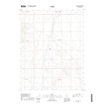
2018 Map of Bailey Wash
USGS Topo · Published 2018About this map
Muleshoe Valley serves as a primary geographical focus for this Lincoln County survey, illustrating the characteristic drainage patterns of the high desert. The landscape is defined by its intermittent watercourses, including the central Coyote Wash and Bailey Wash to the south. These ephemeral systems, alongside Maloy Wash in the northern reaches, dictate the topography and historical travel routes through the region. The map provides a clear look at the Public Land Survey System divisions, featuring sections of Township 5 North, Range 64 East and surrounding areas. For researchers and geologists, this sheet offers a precise record of the alluvial fans and valley floor before subsequent environmental or infrastructural shifts.
Find a feature on this map
5 named features on this map. Tap any name to fly to it.
Don’t see what you’re looking for? This feature index may not catch every label — zoom into the map to look around manually.
Map Details
Editions of this 2018 Bailey Wash Map
This is the sole edition of this map. No revisions or reprints were ever made.
Other maps of this area

1915 · Bristol Range
USGS Topo · 1:62,500

1917 · Bristol Range
USGS Topo · 1:62,500

1956 · Lund
USGS Topo · 1:250,000

1960 · Lund
USGS Topo · 1:250,000
1971 · Silver King Mtn SW
USGS Topo · 1:24,000
1971 · Bristol Well
USGS Topo · 1:24,000

1971 · Bailey Wash
USGS Topo · 1:24,000
1971 · Fairview Peak
USGS Topo · 1:24,000

1971 · Silver King Mtn
USGS Topo · 1:24,000

1971 · Sidehill Pass
USGS Topo · 1:24,000