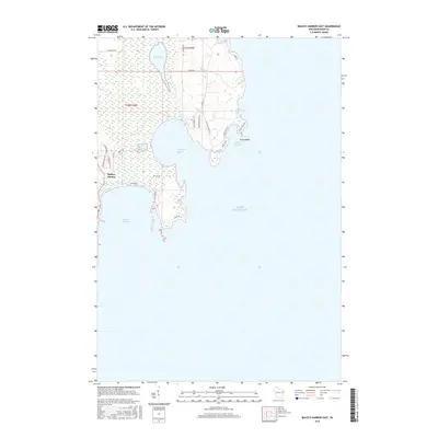
2016 Map of Baileys Harbor East
USGS Topo · Published 2016About this map
Baileys Harbor serves as the focal point of this coastal survey, where the rugged shoreline of Lake Michigan meets the complex wetland systems of the Door Peninsula. The geography is defined by a series of distinct indentations and peninsular features, including the sheltered waters of Moonlight Bay and the smaller Spike Horn Bay. Further inland, the hydrology shifts from the open lake to the more stagnant environments of Mud Lake and Voecks Marsh, illustrating the varied ecosystems that characterize this portion of Wisconsin's coast. The road network, including Ridges Rd and the Old Logging Trl, reflects the area's history of coastal access and forest resource management. Nearby Cana Island stands as a prominent landmark at the edge of Sand Cove, marking a transition between the rocky shoreline and the open waters of the Great Lakes.
Find a feature on this map
27 named features on this map. Tap any name to fly to it.
Don’t see what you’re looking for? This feature index may not catch every label — zoom into the map to look around manually.
Map Details
Editions of this 2016 Baileys Harbor East Map
This is the sole edition of this map. No revisions or reprints were ever made.
Other maps of this area

1954 · Escanaba
USGS Topo · 1:250,000

1954 · Manitowoc
USGS Topo · 1:250,000

1957 · Escanaba
USGS Topo · 1:250,000

1958 · Escanaba
USGS Topo · 1:250,000

1958 · Manitowoc
USGS Topo · 1:250,000

1960 · Jacksonport
USGS Topo · 1:62,500

1960 · Sister Bay
USGS Topo · 1:62,500

1981 · Marinette
USGS Topo · 1:100,000
1982 · Jacksonport
USGS Topo · 1:24,000
1982 · Baileys Harbor West
USGS Topo · 1:24,000