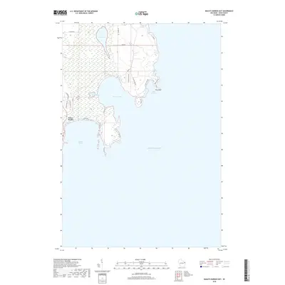
2018 Map of Baileys Harbor East
USGS Topo · Published 2018About this map
Baileys Harbor serves as the focal point for this coastal Door County landscape, where the irregular shoreline of Lake Michigan creates a series of protected inlets and points. The map illustrates a complex relationship between land and water, most notably at Moonlight Bay and the smaller Spike Horn Bay. Near the northeastern corner, Cana Island sits just off the coast, connected by a narrow land bridge near Cana Cove, reflecting the maritime character that has long defined this peninsula.
Find a feature on this map
26 named features on this map. Tap any name to fly to it.
Don’t see what you’re looking for? This feature index may not catch every label — zoom into the map to look around manually.
Map Details
Editions of this 2018 Baileys Harbor East Map
This is the sole edition of this map. No revisions or reprints were ever made.
Other maps of this area

1954 · Escanaba
USGS Topo · 1:250,000

1954 · Manitowoc
USGS Topo · 1:250,000

1957 · Escanaba
USGS Topo · 1:250,000

1958 · Escanaba
USGS Topo · 1:250,000

1958 · Manitowoc
USGS Topo · 1:250,000

1960 · Jacksonport
USGS Topo · 1:62,500

1960 · Sister Bay
USGS Topo · 1:62,500

1981 · Marinette
USGS Topo · 1:100,000
1982 · Jacksonport
USGS Topo · 1:24,000
1982 · Baileys Harbor West
USGS Topo · 1:24,000