
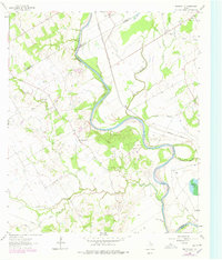
1961 Map of Baileyville
USGS Topo · Published 1964About this map
Baileyville stands as a central settlement in this rural landscape at the intersection of Milam Co, Falls Co, and Robertson Co. The terrain is defined by the winding course of the Brazos River and the parallel Little Brazos River, which includes a notable Little Brazos River Diversion Channel. This 1961 field-checked survey reveals a distributed network of rural life, anchored by small community hubs like Eloise and family-named landmarks such as Hooper Ranch and Salter Farm.
Find a feature on this map
28 named features on this map. Tap any name to fly to it.
Don’t see what you’re looking for? This feature index may not catch every label — zoom into the map to look around manually.
Map Details
Editions of this 1961 Baileyville Map
2 editions found
Other maps of this area

1954 · Waco
USGS Topo · 1:250,000

1954 · Austin
USGS Topo · 1:250,000

1955 · Waco
USGS Topo · 1:250,000

1962 · Calvert
USGS Topo · 1:24,000

1962 · Maysfield
USGS Topo · 1:24,000

1962 · Rosebud
USGS Topo · 1:24,000

1962 · Hammond
USGS Topo · 1:24,000

1962 · Reagan
USGS Topo · 1:24,000
1962 · Ben Arnold
USGS Topo · 1:24,000

1962 · Cedar Springs
USGS Topo · 1:24,000