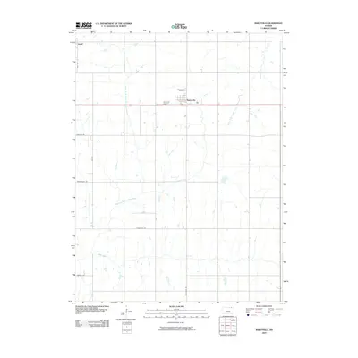
2009 Map of Baileyville
USGS Topo · Published 2009About this map
Baileyville sits at the center of this rural Kansas landscape, where a grid of country roads reflects the methodical organization of the Great Plains. The township is anchored by the Sacred Heart Cemetery and the Baileyville Cemetery, providing significant points of interest for those tracing family ties in the area. The terrain is defined by the winding course of the North Fork Black Vermillion River, which meanders through the western portion of the quadrangle, while South Fork Wildcat Creek and Wever Creek drain the surrounding fields. At the northwestern edge, the outskirts of Axtell appear, connected by a network of local thoroughfares such as Stringtown Rd and Limestone Rd. This survey documents the intersection of agricultural land use and the natural drainage systems that have shaped the development of Marshall County.
Find a feature on this map
14 named features on this map. Tap any name to fly to it.
Don’t see what you’re looking for? This feature index may not catch every label — zoom into the map to look around manually.
Map Details
Editions of this 2009 Baileyville Map
This is the sole edition of this map. No revisions or reprints were ever made.
Other maps of this area

1889 · Seneca
USGS Topo · 1:125,000

1894 · Seneca
USGS Topo · 1:125,000

1955 · Manhattan
USGS Topo · 1:250,000

1956 · Manhattan
USGS Topo · 1:250,000

1957 · Manhattan
USGS Topo · 1:250,000
1966 · St Benedict
USGS Topo · 1:24,000
1966 · Seneca NW
USGS Topo · 1:24,000

1966 · Baileyville
USGS Topo · 1:24,000

1966 · Axtell
USGS Topo · 1:24,000
1966 · Summerfield
USGS Topo · 1:24,000