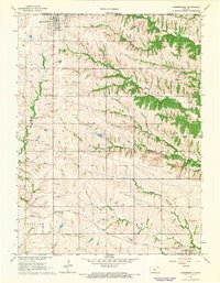
1966 Map of Summerfield
USGS Topo · Published 1967About this map
Summerfield sits at the northern edge of the Kansas border in Marshall County, characterized by the grid-like precision of Midwestern section lines that define the agricultural landscape. This mid-1960s survey captures the region's spiritual and social geography through its numerous cemeteries, including Summerfield Cem, Holy Family Cem, and the remote Shockley Cem. The topography is shaped by the drainage of Robidoux Creek and the North Fork Black Vermillion River, which cut through the townships of Richland and St Bridget. In the southern reaches, the Union Pacific railroad passes through Axtell, connecting this farming district to the wider regional rail economy. The presence of a Landing Field near the state line and a Radio Tower reflects the technological integration of rural Kansas during the mid-century era, while the fine red dashed lines on the map preserve the exact locations of farm fences and field boundaries as they existed during the 1965 aerial photography.
Find a feature on this map
26 named features on this map. Tap any name to fly to it.
Don’t see what you’re looking for? This feature index may not catch every label — zoom into the map to look around manually.
Map Details
Editions of this 1966 Summerfield Map
2 editions found
Other maps of this area

1889 · Seneca
USGS Topo · 1:125,000

1894 · Seneca
USGS Topo · 1:125,000

1955 · Manhattan
USGS Topo · 1:250,000

1955 · Lincoln
USGS Topo · 1:250,000

1956 · Manhattan
USGS Topo · 1:250,000

1957 · Manhattan
USGS Topo · 1:250,000

1957 · Lincoln
USGS Topo · 1:250,000

1958 · Lincoln
USGS Topo · 1:250,000

1965 · Pawnee City
USGS Topo · 1:24,000
1965 · Liberty SE
USGS Topo · 1:24,000