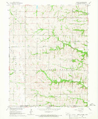
1965 Map of Liberty SE
USGS Topo · Published 1966About this map
The Nebraska-Kansas state line bisects this 1965 survey, marking the transition between Pawnee and Marshall counties. The landscape is defined by the dendritic drainage patterns of Mission Creek, Plum Creek, and West Branch Turkey Creek, which carve through the rural countryside. The settlement of Summerfield sits at the southern edge, serving as a focal point for the surrounding farmsteads. Evidence of earlier infrastructure is visible in the Old Railroad Grade that cuts across the terrain, indicating a shifting transport network as rail lines gave way to improved local roads.
Find a feature on this map
21 named features on this map. Tap any name to fly to it.
Don’t see what you’re looking for? This feature index may not catch every label — zoom into the map to look around manually.
Map Details
Editions of this 1965 Liberty SE Map
This is the sole edition of this map. No revisions or reprints were ever made.
Other maps of this area

1889 · Seneca
USGS Topo · 1:125,000

1894 · Seneca
USGS Topo · 1:125,000

1955 · Manhattan
USGS Topo · 1:250,000

1955 · Lincoln
USGS Topo · 1:250,000

1956 · Manhattan
USGS Topo · 1:250,000

1957 · Manhattan
USGS Topo · 1:250,000

1957 · Lincoln
USGS Topo · 1:250,000

1958 · Lincoln
USGS Topo · 1:250,000

1965 · Pawnee City
USGS Topo · 1:24,000

1965 · Burchard
USGS Topo · 1:24,000