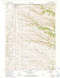
1966 Map of Summerfield
USGS Topo · Published 1983About this map
Summerfield sits at the northern edge of Marshall County, right against the Nebraska Kansas state line. This 1966 survey, with updates from the early 1980s, documents a landscape structured by the Union Pacific railroad and a dense network of country cemeteries and rural townships. To the south, Axtell serves as a secondary hub along the rail corridor, while small communities like St Bridget and Summit anchor the surrounding agricultural districts. The terrain is deeply carved by the North Fork Black Vermillion River and Mantey Creek, creating a complex drainage system that defined the original settlement patterns of Richland and Murray townships. For genealogists, the map is particularly helpful for locating small family or parish burial grounds, including Holy Family Cem, Shockley Cem, and St Michael Cem, which are scattered throughout the hills away from the primary towns.
Find a feature on this map
27 named features on this map. Tap any name to fly to it.
Don’t see what you’re looking for? This feature index may not catch every label — zoom into the map to look around manually.
Map Details
Editions of this 1966 Summerfield Map
2 editions found
Other maps of this area

1889 · Seneca
USGS Topo · 1:125,000

1894 · Seneca
USGS Topo · 1:125,000

1955 · Manhattan
USGS Topo · 1:250,000

1955 · Lincoln
USGS Topo · 1:250,000

1956 · Manhattan
USGS Topo · 1:250,000

1957 · Manhattan
USGS Topo · 1:250,000

1957 · Lincoln
USGS Topo · 1:250,000

1958 · Lincoln
USGS Topo · 1:250,000

1965 · Pawnee City
USGS Topo · 1:24,000
1965 · Liberty SE
USGS Topo · 1:24,000