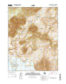
2014 Map of Baird Mountains A-6 SE
USGS Topo · Published 2014About this map
Hotham Inlet dominates the southwestern corner of this coastal Alaskan landscape, where the waters meet the lower reaches of the Baird Mountains. The topography is defined by the transition from tidal flats and coastal waters to the rising elevations of the interior, mapped in detail through the Public Land Survey System grids of t19n r14w, t19n r13w, t20n r14w, and t20n r13w. These townships and ranges provide a precise geographic framework for an area characterized by its lack of established roads or permanent settlements, reflecting the wilderness character of the Northwest Arctic at the time of this 2014 survey. For researchers and historians, the map documents the natural shoreline and elevation contours that define the traditional hunting and fishing grounds of this high-latitude region.
Find a feature on this map
5 named features on this map. Tap any name to fly to it.
Don’t see what you’re looking for? This feature index may not catch every label — zoom into the map to look around manually.
Map Details
Editions of this 2014 Baird Mountains A-6 SE Map
This is the sole edition of this map. No revisions or reprints were ever made.
Other maps of this area

1951 · Baird Mountains
USGS Topo · 1:250,000

1951 · Selawik
USGS Topo · 1:250,000

1951 · Selawik D-6
USGS Topo · 1:63,360

1952 · Selawik D-6
USGS Topo · 1:63,360

1955 · Selawik D-5
USGS Topo · 1:63,360
1955 · Baird Mountains A-5
USGS Topo · 1:63,360
1955 · Baird Mountains A-6
USGS Topo · 1:63,360

1956 · Baird Mountains
USGS Topo · 1:250,000

1957 · Selawik
USGS Topo · 1:250,000

1965 · Baird Mountains
USGS Topo · 1:250,000