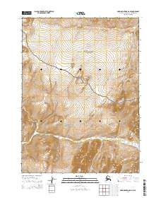
2015 Map of Baird Mountains D-2 SE
USGS Topo · Published 2015About this map
Kobuk Valley National Park and Noatak National Preserve converge in this high-latitude Alaskan landscape, where the federal boundary line cuts through the central terrain. The southern portion of the map is defined by the winding course of the Salmon River, which flows through a wide valley floor marked by intricate elevation contours. This watercourse serves as the primary drainage for the surrounding heights, joined by tributaries such as Kunakok Cr. The absence of man-made structures or improved roads highlights the protected status of these wilderness areas, preserving the natural drainage patterns and topographical character of the Baird Mountains region. This survey captures a remote section of the Northwest Arctic where conservation boundaries dictate the land use, showing the intersection of two major national park units in their primitive state.
Find a feature on this map
10 named features on this map. Tap any name to fly to it.
Don’t see what you’re looking for? This feature index may not catch every label — zoom into the map to look around manually.
Map Details
Editions of this 2015 Baird Mountains D-2 SE Map
This is the sole edition of this map. No revisions or reprints were ever made.
Other maps of this area

1951 · Baird Mountains
USGS Topo · 1:250,000

1956 · Baird Mountains
USGS Topo · 1:250,000

1965 · Baird Mountains
USGS Topo · 1:250,000
1990 · Baird Mountains C-1
USGS Topo · 1:63,360
1990 · Baird Mountains D-1
USGS Topo · 1:63,360
1990 · Baird Mountains D-2
USGS Topo · 1:63,360
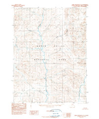
1990 · Baird Mountains C-2
USGS Topo · 1:63,360
2015 · Baird Mountains C-2 NW
USGS Topo · 1:25,000
2015 · Baird Mountains D-2 SW
USGS Topo · 1:25,000
2015 · Baird Mountains C-1 NW
USGS Topo · 1:25,000