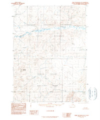
1990 Map of Baird Mountains D-2
USGS Topo · Published 1990About this map
Kobuk Valley National Park and the southern reaches of the Noatak National Preserve meet in this remote Arctic wilderness, where the landscape is defined by the high divides of the Baird Mountains. The terrain transition is marked by the Salmon River, which flows through the southern half of the quadrangle, and the intricate drainage systems of Aklumayuak Creek and Kanaktok Creek to the north and west. Rising prominently above these waterways is Kanaktok Mountain, a significant landmark in a region characterized by its lack of road infrastructure and permanent settlements. This 1990 edition, compiled from 1980 aerial photography, documents the untouched character of the Noatak Wilderness, providing an important baseline for the ecological and topographic state of these protected interior Alaska lands.
Find a feature on this map
8 named features on this map. Tap any name to fly to it.
Don’t see what you’re looking for? This feature index may not catch every label — zoom into the map to look around manually.
Map Details
Editions of this 1990 Baird Mountains D-2 Map
This is the sole edition of this map. No revisions or reprints were ever made.
Other maps of this area

1951 · Baird Mountains
USGS Topo · 1:250,000

1951 · Misheguk Mountain
USGS Topo · 1:250,000

1955 · Baird Mountains D-3
USGS Topo · 1:63,360

1955 · Baird Mountains C-3
USGS Topo · 1:63,360

1956 · Misheguk Mountain
USGS Topo · 1:250,000

1956 · Baird Mountains
USGS Topo · 1:250,000

1965 · Baird Mountains
USGS Topo · 1:250,000
1990 · Misheguk Mountain A-2
USGS Topo · 1:63,360
1990 · Baird Mountains C-1
USGS Topo · 1:63,360
1990 · Misheguk Mountain A-1
USGS Topo · 1:63,360