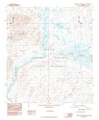
1990 Map of Misheguk Mountain A-2
USGS Topo · Published 1990About this map
The Noatak River serves as the central artery through this remote section of the Northwest Arctic Borough, winding through the vast protected landscapes of the Noatak National Preserve and the Noatak Wilderness. This 1990 provisional study, based on aerial photography from the late 1970s and 1980, reveals a landscape defined by dramatic elevation changes, from the river valley floor to the high peaks of the Kingasivik Mountains. Significant water bodies like Aniralik Lake and Lake Tutusirok are situated north of the Aglungak Hills, while several tributary systems including Nimiuktuk River and Cottonwood Creek feed the main river corridor. This map is particularly valuable for its depiction of the unaltered hydrology of the Brooks Range foothills, showing the complex braids of the Noatak before it continues its westward journey toward the Chukchi Sea.
Find a feature on this map
14 named features on this map. Tap any name to fly to it.
Don’t see what you’re looking for? This feature index may not catch every label — zoom into the map to look around manually.
Map Details
Editions of this 1990 Misheguk Mountain A-2 Map
This is the sole edition of this map. No revisions or reprints were ever made.
Other maps of this area

1951 · Baird Mountains
USGS Topo · 1:250,000

1951 · Misheguk Mountain
USGS Topo · 1:250,000

1955 · Baird Mountains D-3
USGS Topo · 1:63,360

1955 · Misheguk Mountain A-3
USGS Topo · 1:63,360

1956 · Misheguk Mountain
USGS Topo · 1:250,000

1956 · Baird Mountains
USGS Topo · 1:250,000

1965 · Baird Mountains
USGS Topo · 1:250,000
1990 · Misheguk Mountain B-2
USGS Topo · 1:63,360
1990 · Misheguk Mountain B-1
USGS Topo · 1:63,360
1990 · Misheguk Mountain A-1
USGS Topo · 1:63,360