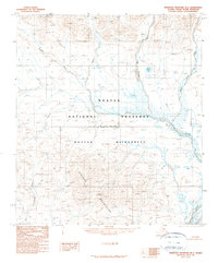
1990 Map of Misheguk Mountain B-1
USGS Topo · Published 1990About this map
The Iggiruk Mountains dominate this remote Alaskan landscape within the Noatak National Preserve. This 1990 provisional survey, based on aerial photography from the late 1970s and 1980, details a wilderness area where the Anisak River winds through the eastern terrain before joining the New River. The topography is defined by high-altitude peaks and a complex drainage system, including the aptly named Sun Setting Creek and Stone Ring Creek. A significant administrative boundary runs east-to-west across the center, marking the division between the South Boundary Umiat Meridian and the North Boundary Kateel River Meridian. The presence of Burial Lake in the northern sector and the vast Noatak Wilderness designation reflect a land preserved in its natural state, devoid of established roads or permanent settlements at the time of mapping.
Find a feature on this map
14 named features on this map. Tap any name to fly to it.
Don’t see what you’re looking for? This feature index may not catch every label — zoom into the map to look around manually.
Map Details
Editions of this 1990 Misheguk Mountain B-1 Map
This is the sole edition of this map. No revisions or reprints were ever made.
Other maps of this area

1951 · Howard Pass
USGS Topo · 1:250,000

1951 · Misheguk Mountain
USGS Topo · 1:250,000

1956 · Howard Pass
USGS Topo · 1:250,000

1956 · Misheguk Mountain
USGS Topo · 1:250,000
1984 · Misheguk Mountain C-1
USGS Topo · 1:63,360
1984 · Misheguk Mountain C-2
USGS Topo · 1:63,360
1984 · Howard Pass C-5
USGS Topo · 1:63,360
1984 · Howard Pass B-5
USGS Topo · 1:63,360
1990 · Misheguk Mountain B-2
USGS Topo · 1:63,360
1990 · Misheguk Mountain A-2
USGS Topo · 1:63,360