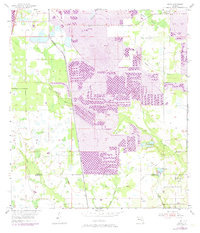
1955 Map of Baird
USGS Topo · Published 1973About this map
Large industrial operations dominate the central corridor of this Florida landscape, where extensive Strip Mine works and a sprawling Mine Dump define the terrain north of Baird. The map captures a period of significant land modification, with the Seaboard Coast Line railroad providing the essential transport link for the region's phosphate industry. In contrast to the industrial zones, the eastern and western edges of the sheet maintain more natural drainage patterns, including the winding course of Little Payne Creek and the marshy expanse of Hookers Prairie. Religious and community life is anchored by Welcome Ch in the northeast and Payne Creek Ch near the Polk Co Hardee Co line. A remnant of earlier transport infrastructure, an Old Railroad Grade, cuts through the southern sections, while the Pierce Lookout Tower stands as a prominent local landmark overlooking the industrial and prairie interface.
Find a feature on this map
15 named features on this map. Tap any name to fly to it.
Don’t see what you’re looking for? This feature index may not catch every label — zoom into the map to look around manually.
Map Details
Editions of this 1955 Baird Map
4 editions found
Other maps of this area

1949 · Bradley Junction
USGS Topo · 1:24,000

1950 · Bradley Junction
USGS Topo · 1:24,000

1952 · Homeland
USGS Topo · 1:24,000

1955 · Ft. Green
USGS Topo · 1:24,000

1955 · Bowling Green
USGS Topo · 1:24,000

1955 · Wauchula
USGS Topo · 1:24,000

1955 · Baird
USGS Topo · 1:24,000

1955 · Keysville
USGS Topo · 1:24,000

1956 · Duette NE
USGS Topo · 1:24,000

1956 · Duette
USGS Topo · 1:24,000