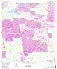
1955 Map of Baird
USGS Topo · Published 1987About this map
Phosphate mining defines the industrial character of this landscape along the border of Polk and Hardee counties. The central corridor is dominated by a sprawling Strip Mine complex, with extensive areas marked as reclaimed strip mine and numerous mine dumps altering the natural drainage. Amidst this heavy earth-moving activity, the settlement of Baird and the Substa outpost stand near the rail lines, while local life persists at Welcome Ch and Payne Creek Ch. The geography is a study in transition, where water features like Hookers Prairie and Little Payne Creek navigate around industrial excavations. An Old Railroad Grade and an Old RR Grade trace former transport routes, signaling the long-standing importance of heavy industry to the region's economy.
Find a feature on this map
19 named features on this map. Tap any name to fly to it.
Don’t see what you’re looking for? This feature index may not catch every label — zoom into the map to look around manually.
Map Details
Editions of this 1955 Baird Map
4 editions found
Other maps of this area

1949 · Bradley Junction
USGS Topo · 1:24,000

1950 · Bradley Junction
USGS Topo · 1:24,000

1952 · Homeland
USGS Topo · 1:24,000

1955 · Ft. Green
USGS Topo · 1:24,000

1955 · Bowling Green
USGS Topo · 1:24,000

1955 · Wauchula
USGS Topo · 1:24,000

1955 · Baird
USGS Topo · 1:24,000

1955 · Keysville
USGS Topo · 1:24,000

1956 · Duette NE
USGS Topo · 1:24,000

1956 · Duette
USGS Topo · 1:24,000