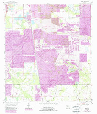
1955 Map of Baird
USGS Topo · Published 1987About this map
Strip mining operations dominate this central Florida landscape, revealing a period of significant industrial transition as phosphate extraction reshaped the terrain. The map meticulously documents the contrast between active extraction zones and a Reclaimed Strip Mine, reflecting early attempts at land restoration. At the center of this industrial activity lies the small settlement of Baird, which serves as a focal point amidst the sprawling pits and waste piles.
Find a feature on this map
18 named features on this map. Tap any name to fly to it.
Don’t see what you’re looking for? This feature index may not catch every label — zoom into the map to look around manually.
Map Details
Editions of this 1955 Baird Map
4 editions found
Other maps of this area

1949 · Bradley Junction
USGS Topo · 1:24,000

1950 · Bradley Junction
USGS Topo · 1:24,000

1952 · Homeland
USGS Topo · 1:24,000

1955 · Ft. Green
USGS Topo · 1:24,000

1955 · Bowling Green
USGS Topo · 1:24,000

1955 · Wauchula
USGS Topo · 1:24,000

1955 · Baird
USGS Topo · 1:24,000

1955 · Keysville
USGS Topo · 1:24,000

1956 · Duette NE
USGS Topo · 1:24,000

1956 · Duette
USGS Topo · 1:24,000