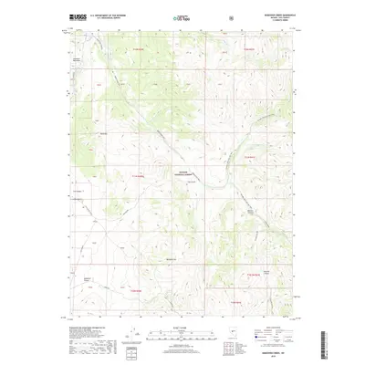
2018 Map of Bakeoven Creek
USGS Topo · Published 2018About this map
Toiyabe National Forest dominates this high-altitude landscape in Nye County, where a complex network of canyons and peaks defines the central Nevada wilderness. This 2018 survey documents a remote backcountry terrain shaped by seasonal watercourses like Bakeoven Cr, Illinois Cr, and the Reese River. The map highlights a significant intersection of recreational corridors, most notably the Toiyabe Crest Natl Rec Trail and the Reese River Trail, which serve as the primary conduits through this roadless area. Local landmarks such as Black Mtn, Mahogany Hill, and Indian Valley provide essential orientation for navigation between the deep cuts of Cow Canyon and Peavine Canyon. The presence of Ledbetter Spring indicates critical water sources in an otherwise arid environment, essential for those tracing the historic routes and natural features of the Shoshone Mountains.
Find a feature on this map
44 named features on this map. Tap any name to fly to it.
Don’t see what you’re looking for? This feature index may not catch every label — zoom into the map to look around manually.
Map Details
Editions of this 2018 Bakeoven Creek Map
This is the sole edition of this map. No revisions or reprints were ever made.
Other maps of this area

1907 · Tonopah
USGS Topo · 1:250,000

1908 · Tonopah
USGS Topo · 1:250,000

1948 · Ione
USGS Topo · 1:62,500

1950 · Ione
USGS Topo · 1:62,500

1956 · Tonopah
USGS Topo · 1:250,000

1959 · Tonopah
USGS Topo · 1:250,000

1962 · Tonopah
USGS Topo · 1:250,000
1979 · Corral Wash
USGS Topo · 1:24,000
1979 · Toiyabe Peak
USGS Topo · 1:24,000
1980 · Arc Dome
USGS Topo · 1:24,000