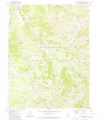
1980 Map of Bakeoven Creek
USGS Topo · Published 1980About this map
The Reese River carves a path between the high ridges of the Toiyabe Range and the Shoshone Mountains in this high-desert Nevada landscape. At the northern edge, a portion of the Yomba Indian Res borders the Toiyabe National Forest, marking a region of overlapping heritage and land use. The map reveals a rugged backcountry accessible only by a Jeep Trail or Pack Trail, connecting isolated points of interest such as the Stone Cabin and Potosi Cabin.
Find a feature on this map
30 named features on this map. Tap any name to fly to it.
Don’t see what you’re looking for? This feature index may not catch every label — zoom into the map to look around manually.
Map Details
Editions of this 1980 Bakeoven Creek Map
This is the sole edition of this map. No revisions or reprints were ever made.
Other maps of this area

1907 · Tonopah
USGS Topo · 1:250,000

1908 · Tonopah
USGS Topo · 1:250,000

1948 · Ione
USGS Topo · 1:62,500

1950 · Ione
USGS Topo · 1:62,500

1956 · Tonopah
USGS Topo · 1:250,000

1959 · Tonopah
USGS Topo · 1:250,000

1962 · Tonopah
USGS Topo · 1:250,000
1979 · Corral Wash
USGS Topo · 1:24,000
1979 · Toiyabe Peak
USGS Topo · 1:24,000
1980 · Arc Dome
USGS Topo · 1:24,000