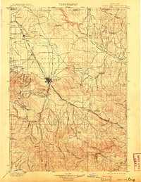
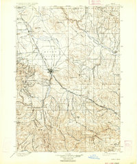
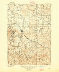
1901 Map of Baker City
USGS Topo · Published 1909About this map
Baker City serves as the focal point of this Eastern Oregon survey, situated at the meeting of the Baker Valley and the steep mountain gulches to the west. The landscape is defined by its industrial transit networks, most notably the Oregon Railroad and Navigation Company and the Sumpter Valley Railroad, which facilitated the movement of ore and timber from the surrounding highlands. Mining activity is prominently recorded at the Flagstaff Mine and Virtue Mine on Virtue Flat, highlighting the mineral-rich nature of the terrain during this era.
Find a feature on this map
89 named features on this map. Tap any name to fly to it.
Don’t see what you’re looking for? This feature index may not catch every label — zoom into the map to look around manually.
Map Details
Editions of this 1901 Baker City Map
4 editions found
Other maps of this area

1901 · Baker City
USGS Topo · 1:125,000

1901 · Sumpter
USGS Topo · 1:125,000

1906 · Telocaset
USGS Topo · 1:125,000

1908 · Ironside Mountain
USGS Topo · 1:125,000

1915 · Pine
USGS Topo · 1:125,000
1951 · Huntington
USGS Topo · 1:62,500

1953 · Pendleton
USGS Topo · 1:250,000

1954 · Eagle Cap
USGS Topo · 1:62,500

1955 · Baker
USGS Topo · 1:250,000

1955 · Grangeville
USGS Topo · 1:250,000