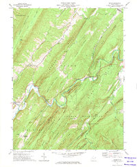
1971 Map of Baker
USGS Topo · Published 1974About this map
The Lost River meanders through this West Virginia landscape, notable for the geological phenomena where the water literally vanishes at River Sinks and reappears at River Emerges. The settlement of Baker serves as a local hub, featuring the Baker Sch and proximity to the Baughman Settlement. For family historians and industrial archaeologists, the map records several rural landmarks including the Mt Moriah Ch, Sperry Run Ch, and a site marked Old Iron Furnace near Trout Run.
Find a feature on this map
60 named features on this map. Tap any name to fly to it.
Don’t see what you’re looking for? This feature index may not catch every label — zoom into the map to look around manually.
Map Details
Editions of this 1971 Baker Map
This is the sole edition of this map. No revisions or reprints were ever made.
Other maps of this area

1891 · Romney
USGS Topo · 1:125,000

1892 · Woodstock
USGS Topo · 1:125,000

1920 · Moorefield
USGS Topo · 1:62,500

1921 · Orkney Springs
USGS Topo · 1:48,000

1921 · Moorefield
USGS Topo · 1:48,000

1922 · Moorefield
USGS Topo · 1:62,500

1922 · Wardensville
USGS Topo · 1:62,500

1923 · Orkney Springs
USGS Topo · 1:62,500

1923 · Edinburg
USGS Topo · 1:62,500

1924 · Wardensville
USGS Topo · 1:62,500