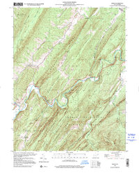
1999 Map of Baker
USGS Topo · Published 2001About this map
The Lost River carves a deep path through the corrugated ridges of Hardy County, where the village of Baker and the nearby Baker Sch anchor the local community. This survey details the complex geography of the George Washington National Forest, where the landscape is defined by parallel heights like Warden Ridge and Capon Ridge. The map reveals several distinct mountain hollows and gaps, including Squirrel Gap and Wise Gap, which dictate the movement of early roads and 4WD tracks through the terrain.
Find a feature on this map
55 named features on this map. Tap any name to fly to it.
Don’t see what you’re looking for? This feature index may not catch every label — zoom into the map to look around manually.
Map Details
Editions of this 1999 Baker Map
This is the sole edition of this map. No revisions or reprints were ever made.
Other maps of this area

1891 · Romney
USGS Topo · 1:125,000

1892 · Woodstock
USGS Topo · 1:125,000

1920 · Moorefield
USGS Topo · 1:62,500

1921 · Orkney Springs
USGS Topo · 1:48,000

1921 · Moorefield
USGS Topo · 1:48,000

1922 · Moorefield
USGS Topo · 1:62,500

1922 · Wardensville
USGS Topo · 1:62,500

1923 · Orkney Springs
USGS Topo · 1:62,500

1923 · Edinburg
USGS Topo · 1:62,500

1924 · Wardensville
USGS Topo · 1:62,500