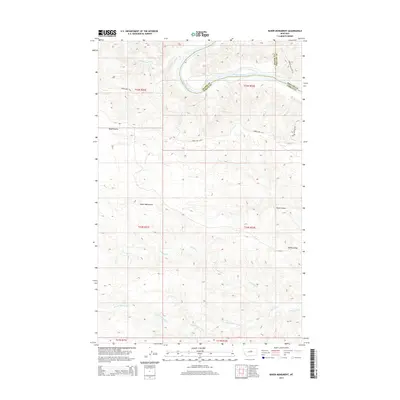
2014 Map of Baker Monument
USGS Topo · Published 2014About this map
The Missouri River carves a sharp northerly bend through this section of central Montana, defining the shared borders of Fergus, Blaine, and Phillips counties. This landscape is dominated by the complex drainage systems of Woodhawk Cr and the various branches of Two Calf Cr, which have sculpted the terrain into prominent features like Barnes Ridge and the Reed Coulee depressions. Historical transit patterns are visible in the naming of riverfront areas such as Woodhawk Btm and the access provided by Power Plant Ferry Rd, pointing to the importance of river crossings and bottomland access in this remote region. The namesake Baker Monument stands as a notable landmark overlooking the breaks and coulees, where the D-Y Trl and Keller Bottom Rd provide the primary terrestrial movement through the high country.
Find a feature on this map
21 named features on this map. Tap any name to fly to it.
Don’t see what you’re looking for? This feature index may not catch every label — zoom into the map to look around manually.
Map Details
Editions of this 2014 Baker Monument Map
This is the sole edition of this map. No revisions or reprints were ever made.
Other maps of this area

1943 · Landusky
USGS Topo · 1:125,000

1954 · Cow Island
USGS Topo · 1:24,000

1954 · Baker Monument
USGS Topo · 1:24,000

1954 · Sturgeon Island
USGS Topo · 1:24,000

1954 · Grand Island
USGS Topo · 1:24,000

1954 · Lewistown
USGS Topo · 1:250,000

1959 · Lewistown
USGS Topo · 1:250,000
1971 · Shetland Divide
USGS Topo · 1:24,000

1984 · Zortman
USGS Topo · 1:100,000

1985 · Thompson Coulee
USGS Topo · 1:24,000