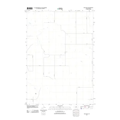
2012 Map of Bald Hills
USGS Topo · Published 2012About this map
Bald Hills define the terrain of this rural Potter County landscape, where the survey reveals a sparse but methodical grid of section roads and section lines. This 2012 snapshot of central South Dakota shows a transition in infrastructure, where major corridors like Co Hwy-3 and Ellisville Ave anchor the eastern edge of the quadrangle. The interior is defined by long, straight gravel and dirt paths such as 331st Ave and 173rd St, which navigate the subtle rises of the hills and the occasional prairie pothole or intermittent drainage. Genealogists and local historians will find the exact alignment of these rural routes essential for locating ancestral homesteads or family farmsteads that defined the local agricultural economy in the early 21st century.
Find a feature on this map
19 named features on this map. Tap any name to fly to it.
Don’t see what you’re looking for? This feature index may not catch every label — zoom into the map to look around manually.
Map Details
Editions of this 2012 Bald Hills Map
This is the sole edition of this map. No revisions or reprints were ever made.
Other maps of this area

1951 · Rice Lake
USGS Topo · 1:24,000

1951 · Rezac Lake NW
USGS Topo · 1:24,000

1952 · Onaka SW
USGS Topo · 1:24,000

1953 · Huron
USGS Topo · 1:250,000

1954 · Aberdeen
USGS Topo · 1:250,000

1954 · Huron
USGS Topo · 1:250,000

1956 · Aberdeen
USGS Topo · 1:250,000
1978 · Bald Hills
USGS Topo · 1:24,000
1978 · Thomas Lake
USGS Topo · 1:24,000
1978 · Thomas Lake SW
USGS Topo · 1:24,000