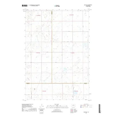
2017 Map of Bald Hills
USGS Topo · Published 2017About this map
The Bald Hills rise as a distinctive landform in this sparsely populated stretch of the Great Plains, where the borders of three South Dakota counties converge. Surveyed in 2017, the area is defined by its section-line road network and the intersection of Potter, Faulk, and Hyde counties. The landscape is dotted with numerous small wetlands and prairie potholes typical of the region's glaciated geography. Transportation is anchored by local routes such as Co Rd 3 and Co Rd 12, along with the Holabird Grade which cuts across the southwestern corner of the quadrangle. This map serves as a detailed record of the rural infrastructure and natural drainage patterns in a remote agricultural environment, highlighting the precise township and range divisions including t117n r73w and t118n r72w.
Find a feature on this map
24 named features on this map. Tap any name to fly to it.
Don’t see what you’re looking for? This feature index may not catch every label — zoom into the map to look around manually.
Map Details
Editions of this 2017 Bald Hills Map
This is the sole edition of this map. No revisions or reprints were ever made.
Other maps of this area

1951 · Rice Lake
USGS Topo · 1:24,000

1951 · Rezac Lake NW
USGS Topo · 1:24,000

1952 · Onaka SW
USGS Topo · 1:24,000

1953 · Huron
USGS Topo · 1:250,000

1954 · Aberdeen
USGS Topo · 1:250,000

1954 · Huron
USGS Topo · 1:250,000

1956 · Aberdeen
USGS Topo · 1:250,000
1978 · Bald Hills
USGS Topo · 1:24,000
1978 · Thomas Lake
USGS Topo · 1:24,000
1978 · Thomas Lake SW
USGS Topo · 1:24,000