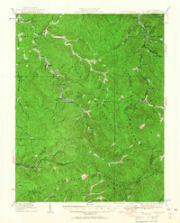
1928 Map of Bald Knob
USGS Topo · Published 1956About this map
Cherry Pond Mountain and Cook Mountain dominate this corner of West Virginia during a period of industrial expansion into the coalfields. The Chesapeake and Ohio railroad follows the winding drainages, connecting coal-rich settlements like Lorado, Pardee, and Wharton to the outside world. This 1928 revision by G.E.Sisson documents a network of rural ridge-top and valley communities identified by local schools and post offices, such as Ball Creek Sch, Jackson (Bim PO), and Toney Fork Sch.
Find a feature on this map
118 named features on this map. Tap any name to fly to it.
Don’t see what you’re looking for? This feature index may not catch every label — zoom into the map to look around manually.
Map Details
Editions of this 1928 Bald Knob Map
This is the sole edition of this map. No revisions or reprints were ever made.
Other maps of this area

1891 · Oceana
USGS Topo · 1:125,000

1891 · Raleigh
USGS Topo · 1:125,000

1893 · Oceana
USGS Topo · 1:125,000

1897 · Kanawha Falls
USGS Topo · 1:125,000

1897 · Raleigh
USGS Topo · 1:125,000

1898 · Oceana
USGS Topo · 1:125,000

1899 · Charleston
USGS Topo · 1:125,000

1900 · Kanawha Falls
USGS Topo · 1:125,000

1901 · Kanawha Falls
USGS Topo · 1:125,000

1902 · Raleigh
USGS Topo · 1:125,000