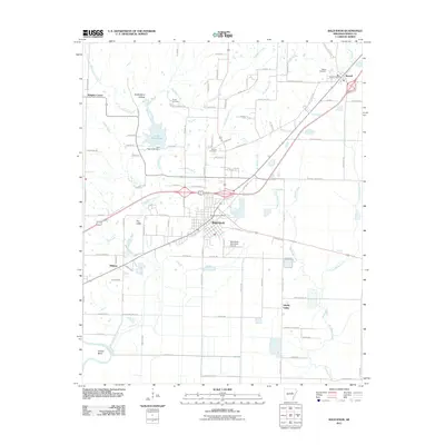
2011 Map of Bald Knob
USGS Topo · Published 2011About this map
Bald Knob serves as the central hub of this northeast Arkansas landscape, where the confluence of regional drainage and transportation corridors defines the local geography. The map illustrates a transition from the structured street grid of the town to the surrounding rural reaches of Liberty Valley and Wrights Corner. Waterways like Big Mingo Creek and Overflow Creek meander through the terrain, with Lake Bald Knob and the Lake Bald Knob Dam situated just north of the primary settlement.
Find a feature on this map
99 named features on this map. Tap any name to fly to it.
Don’t see what you’re looking for? This feature index may not catch every label — zoom into the map to look around manually.
Map Details
Editions of this 2011 Bald Knob Map
This is the sole edition of this map. No revisions or reprints were ever made.
Other maps of this area

1932 · Kensett
USGS Topo · 1:62,500

1935 · Kensett
USGS Topo · 1:62,500

1935 · Augusta
USGS Topo · 1:62,500

1935 · Gregory
USGS Topo · 1:62,500

1935 · Bald Knob
USGS Topo · 1:62,500

1953 · Memphis
USGS Topo · 1:250,000

1956 · Memphis
USGS Topo · 1:250,000

1957 · Augusta
USGS Topo · 1:62,500

1957 · Gregory
USGS Topo · 1:62,500
1964 · Kensett
USGS Topo · 1:24,000