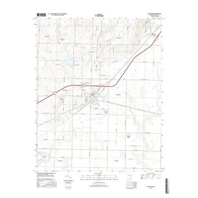
2017 Map of Bald Knob
USGS Topo · Published 2017About this map
Bald Knob serves as the central hub of this White County survey, where the convergence of major transit routes and the local landscape is meticulously documented. The settlement pattern extends north to Russell and south toward Liberty Valley, revealing a community deeply connected to its land through numerous family and local burial sites like Prince Cem, Bolden Cem, and Pleasant Grove Cem. The topography is defined by the winding course of Overflow Cr and Big Mingo Cr, which drain the lowlands surrounding Lake Bald Knob. To the north, the elevation rises toward Russell Mtn, while the southwestern corner is marked by the sharp bend of the Little Red River at Conley Bend. This modern record also details the local aviation infrastructure at the Bald Knob Municipal Airport, providing a clear view of the area's contemporary rural and civic layout.
Find a feature on this map
90 named features on this map. Tap any name to fly to it.
Don’t see what you’re looking for? This feature index may not catch every label — zoom into the map to look around manually.
Map Details
Editions of this 2017 Bald Knob Map
This is the sole edition of this map. No revisions or reprints were ever made.
Other maps of this area

1932 · Kensett
USGS Topo · 1:62,500

1935 · Kensett
USGS Topo · 1:62,500

1935 · Augusta
USGS Topo · 1:62,500

1935 · Gregory
USGS Topo · 1:62,500

1935 · Bald Knob
USGS Topo · 1:62,500

1953 · Memphis
USGS Topo · 1:250,000

1956 · Memphis
USGS Topo · 1:250,000

1957 · Augusta
USGS Topo · 1:62,500

1957 · Gregory
USGS Topo · 1:62,500
1964 · Kensett
USGS Topo · 1:24,000