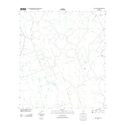
2013 Map of Bald Mound
USGS Topo · Published 2013About this map
Bald Mound rises as a distinct landmark above a complex network of seasonal creeks and ranch roads in this rural section of Wilson County. The landscape is defined by its drainage patterns, where Mound Cr and Board Br draw water toward the southeast. Agriculture and ranching remain the primary drivers of land use, evidenced by the numerous farm-to-market and county roads such as FM 108 and Co RD 170 that crisscross the terrain. Small private developments and infrastructure like Joye Ranch Airport and the waters of Kelly Lake suggest a modern layer of settlement on a terrain historically anchored by features like Rocky Mound. This map captures the area's transition into the 21st century, balancing traditional ranching with rural residential growth.
Find a feature on this map
42 named features on this map. Tap any name to fly to it.
Don’t see what you’re looking for? This feature index may not catch every label — zoom into the map to look around manually.
Map Details
Editions of this 2013 Bald Mound Map
This is the sole edition of this map. No revisions or reprints were ever made.
Other maps of this area

1920 · Smiley
USGS Topo · 1:125,000

1942 · Dewville
USGS Topo · 1:62,500

1953 · Seguin
USGS Topo · 1:250,000

1956 · Dewville
USGS Topo · 1:62,500

1958 · Seguin
USGS Topo · 1:250,000

1961 · Sample
USGS Topo · 1:24,000

1961 · Nixon
USGS Topo · 1:24,000
1961 · Pilgrim
USGS Topo · 1:24,000

1961 · New Davy
USGS Topo · 1:24,000

1961 · Gillett
USGS Topo · 1:24,000