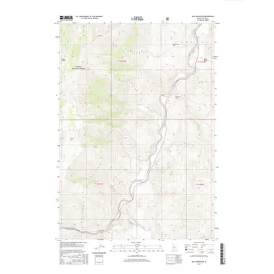
2017 Map of Bald Mountain
USGS Topo · Published 2017About this map
The Salmon River carves a deep path through Custer County, winding past the eastern edge of the Challis National Forest. This 2017 survey illustrates a high-altitude landscape defined by its drainages and plateau-like flats, where the East Fork Salmon River meets the main stem in the southern reaches. The terrain is marked by distinctive named locations such as Centennial Flat and Povert Flat, which suggest a history of early grazing or settlement attempts in this unforgiving environment. Access to the backcountry is limited to thoroughfares like River Rd and E Fork Rd, which follow the watercourses through steep canyons. Local history researchers can trace the seasonal hydrology of the region through numerous named tributaries, including Juliette Cr, Rattlesnake Cr, and the isolated Alkali Spring.
Find a feature on this map
22 named features on this map. Tap any name to fly to it.
Don’t see what you’re looking for? This feature index may not catch every label — zoom into the map to look around manually.
Map Details
Editions of this 2017 Bald Mountain Map
This is the sole edition of this map. No revisions or reprints were ever made.
Other maps of this area

1929 · Bayhorse
USGS Topo · 1:125,000

1957 · Challis
USGS Topo · 1:250,000

1960 · Challis
USGS Topo · 1:250,000

1963 · Challis
USGS Topo · 1:250,000

1963 · Bald Mountain
USGS Topo · 1:24,000

1963 · Bayhorse Lake
USGS Topo · 1:24,000

1963 · Bayhorse
USGS Topo · 1:24,000

1963 · Clayton
USGS Topo · 1:24,000
1963 · Ziegler Basin
USGS Topo · 1:24,000
1963 · Potaman Peak
USGS Topo · 1:24,000