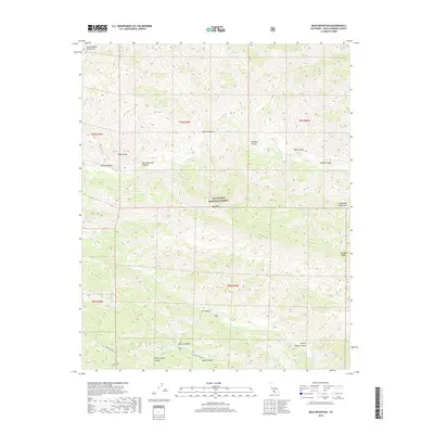
2018 Map of Bald Mountain
USGS Topo · Published 2018About this map
The Los Padres National Forest encompasses this wilderness area where the Sierra Madre Mountains and the San Rafael Mountains converge. The drainage system is defined by the Sisquoc River flowing through the northern half and the Manzana Cr cutting through the southern portion, reflecting the complex topography of Santa Barbara County. Notable peaks such as Wheat Peak and Bald Mtn stand above a series of named drainages, including Wellman Canyon and Miller Canyon. While mostly roadless, the southwestern corner is accessible via Sunset Valley Rd and Catway Rd, leading into Sunset Valley. This corridor provides a point of entry into a landscape marked by numerous springs and seasonal watercourses like Davy Brown Cr and Fish Cr, which have long served as vital landmarks in this arid mountain environment.
Find a feature on this map
29 named features on this map. Tap any name to fly to it.
Don’t see what you’re looking for? This feature index may not catch every label — zoom into the map to look around manually.
Map Details
Editions of this 2018 Bald Mountain Map
This is the sole edition of this map. No revisions or reprints were ever made.
Other maps of this area

1902 · Santa Ynez
USGS Topo · 1:125,000

1905 · Santa Ynez
USGS Topo · 1:125,000

1905 · Lompoc
USGS Topo · 1:125,000

1941 · San Rafael Mtn.
USGS Topo · 1:62,500

1941 · McPherson Peak
USGS Topo · 1:62,500

1942 · Lompoc
USGS Topo · 1:125,000

1942 · San Rafael Mtn.
USGS Topo · 1:62,500

1942 · Tepusquet Peak
USGS Topo · 1:62,500

1942 · Los Olivos
USGS Topo · 1:62,500

1943 · San Rafael Mtn.
USGS Topo · 1:62,500