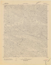
1965 Map of Bald Mountain
USGS Topo · Published 1965About this map
Los Padres National Forest hosts a network of backcountry sites and rugged terrain in this 1965 manuscript sheet. The topography is dominated by the Sierra Madre Mountains and the San Rafael Mountains, separated by the Sisquoc River valley. This unedited copy captures the landscape before formal publication, showing numerous remote outposts like Manzana Camp and Water Canyon Camp. Evidence of human passage is etched into the canyons through the Mule Trail and Bald Mountain Trail, which traverse ridges like the curiously named Hurricane Deck. Cultural traces are sparse but significant, including identified Ruins and a lone Grave near Wellman Canyon. The southern portion of the map transitions into Sunset Valley, where Davey Brown Camp and Nira Camp are situated along the tributaries of Manzana Creek.
Find a feature on this map
41 named features on this map. Tap any name to fly to it.
Don’t see what you’re looking for? This feature index may not catch every label — zoom into the map to look around manually.
Map Details
Editions of this 1965 Bald Mountain Map
This is the sole edition of this map. No revisions or reprints were ever made.
Other maps of this area

1902 · Santa Ynez
USGS Topo · 1:125,000

1905 · Santa Ynez
USGS Topo · 1:125,000

1905 · Lompoc
USGS Topo · 1:125,000

1941 · San Rafael Mtn.
USGS Topo · 1:62,500

1941 · McPherson Peak
USGS Topo · 1:62,500

1942 · Lompoc
USGS Topo · 1:125,000

1942 · San Rafael Mtn.
USGS Topo · 1:62,500

1942 · Tepusquet Peak
USGS Topo · 1:62,500

1942 · Los Olivos
USGS Topo · 1:62,500

1943 · San Rafael Mtn.
USGS Topo · 1:62,500