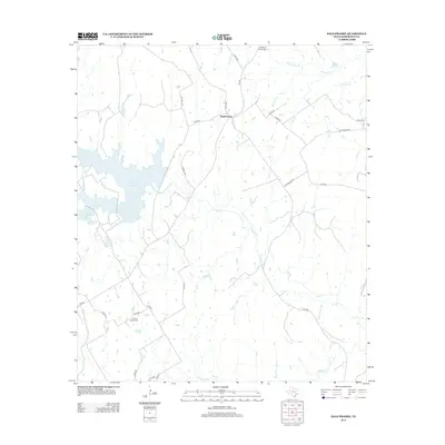
2013 Map of Bald Prairie
USGS Topo · Published 2013About this map
Bald Prairie sits at the heart of this Robertson County landscape, where the rural character of Central Texas is defined by a network of creeks and local cemeteries. The northern reaches are drained by Pin Oak Cr and Schoolhouse Br, while the substantial Twin Oak Reservoir dominates the western edge, providing a large water body in an otherwise creek-dissected terrain. This 2013 survey illustrates a transition from traditional agricultural land use to modern utility, evident in the reservoir's presence alongside old thoroughfares like Cole Branch Rd and Oil Well Rd. Genealogists will find particular value in the documentation of Wesley Chapel Cem and E Boone Prairie Cem, which serve as quiet markers of the area's long-standing community roots. Numerous watercourses, including Duck Cr and Mulberry Cr, weave through the quadrangle, illustrating the natural drainage patterns that have shaped local settlement for generations.
Find a feature on this map
31 named features on this map. Tap any name to fly to it.
Don’t see what you’re looking for? This feature index may not catch every label — zoom into the map to look around manually.
Map Details
Editions of this 2013 Bald Prairie Map
This is the sole edition of this map. No revisions or reprints were ever made.
Other maps of this area

1925 · Marquez No. 1
USGS Topo · 1:48,000

1925 · Marquez No. 4
USGS Topo · 1:48,000

1927 · Marquez
USGS Topo · 1:62,500

1930 · Marquez
USGS Topo · 1:62,500

1954 · Waco
USGS Topo · 1:250,000

1955 · Waco
USGS Topo · 1:250,000

1962 · Petteway
USGS Topo · 1:24,000
1962 · Owensville
USGS Topo · 1:24,000
1965 · Marquez
USGS Topo · 1:24,000
1965 · Camp Creek Lake
USGS Topo · 1:24,000