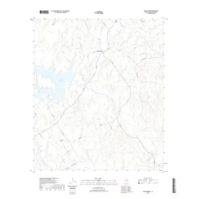
2019 Map of Bald Prairie
USGS Topo · Published 2019About this map
Bald Prairie sits at the heart of this Robertson County landscape, a rural community defined by its rolling creek networks and quiet burial grounds. The western edge of the sheet is dominated by the sprawling waters of Twin Oak Reservoir, fed by Heads Branch, which provides a significant contrast to the surrounding ranch land and wooded creek bottoms. The area is heavily intersected by local routes like FM 979 and FM 2096, tracing the path of earlier settlement through the prairie. Family and community history is preserved at several distinct sites, including the Wesley Chapel Cem, Thompson Cem, and East Boone Prairie Cem. The drainage pattern is complex, with Duck Cr, Mineral Cr, and Mulberry Cr carving through the terrain, suggesting a landscape historically tied to livestock and local agriculture rather than dense industrial development.
Find a feature on this map
38 named features on this map. Tap any name to fly to it.
Don’t see what you’re looking for? This feature index may not catch every label — zoom into the map to look around manually.
Map Details
Editions of this 2019 Bald Prairie Map
This is the sole edition of this map. No revisions or reprints were ever made.
Other maps of this area

1925 · Marquez No. 1
USGS Topo · 1:48,000

1925 · Marquez No. 4
USGS Topo · 1:48,000

1927 · Marquez
USGS Topo · 1:62,500

1930 · Marquez
USGS Topo · 1:62,500

1954 · Waco
USGS Topo · 1:250,000

1955 · Waco
USGS Topo · 1:250,000

1962 · Petteway
USGS Topo · 1:24,000
1962 · Owensville
USGS Topo · 1:24,000
1965 · Marquez
USGS Topo · 1:24,000
1965 · Camp Creek Lake
USGS Topo · 1:24,000