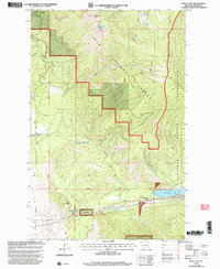
1999 Map of Baldy Lake
USGS Topo · Published 2003About this map
Lolo National Forest and the Flathead Indian Reservation meet across this mountainous terrain, where high-altitude water features like Baldy Lake and Banana Lake drain through complex creek systems. Near the western edge, the intersection at Blanchards Corner serves as a lone point of reference for local navigation. The landscape is defined by the steep transition at Rainbow Lake Pass and the presence of the McGinnis Ditch in the northeast, suggesting early 20th-century water management efforts to divert flows from McGinnis Creek. This 1999 revision, based on surveys from 1964 and imagery from 1995, documents the remote topography around Baldy Mountain and Locust Hill before modern infrastructure changes. The boundary lines of the Fifth Standard Parallel North and the Guide Meridian provide the surveyor's framework for these wildlands.
Find a feature on this map
16 named features on this map. Tap any name to fly to it.
Don’t see what you’re looking for? This feature index may not catch every label — zoom into the map to look around manually.
Map Details
Editions of this 1999 Baldy Lake Map
This is the sole edition of this map. No revisions or reprints were ever made.
Other maps of this area

1956 · Wallace
USGS Topo · 1:250,000

1959 · Perma
USGS Topo · 1:62,500

1959 · Plains
USGS Topo · 1:62,500

1960 · Wallace
USGS Topo · 1:250,000

1964 · Coney Peak
USGS Topo · 1:24,000

1964 · Baldy Lake
USGS Topo · 1:24,000

1964 · Weeksville
USGS Topo · 1:24,000

1964 · Lonepine
USGS Topo · 1:24,000

1964 · Hot Springs
USGS Topo · 1:24,000
1964 · Loneman Creek
USGS Topo · 1:24,000