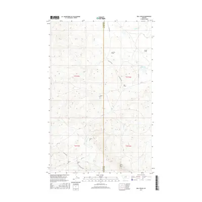
2017 Map of Ball Coulee
USGS Topo · Published 2017About this map
Judith River Ridge defines the southern portion of this landscape, where the high ground transitions toward the drainages of Big Warm Cr and Wild Horse Cr. The boundary between Blaine County and Phillips County runs vertically through the center of the survey, a divide marked by isolated family-named cemeteries and a network of rural roads such as Chopwood Rd and Boom Messerly Rd. These labels reflect the long-standing ranching and homesteading heritage of the Lodge Pole District.
Find a feature on this map
25 named features on this map. Tap any name to fly to it.
Don’t see what you’re looking for? This feature index may not catch every label — zoom into the map to look around manually.
Map Details
Editions of this 2017 Ball Coulee Map
This is the sole edition of this map. No revisions or reprints were ever made.
Other maps of this area

1943 · Landusky
USGS Topo · 1:125,000

1953 · Havre
USGS Topo · 1:250,000

1954 · Lewistown
USGS Topo · 1:250,000

1957 · Havre
USGS Topo · 1:250,000

1958 · Havre
USGS Topo · 1:250,000

1959 · Lewistown
USGS Topo · 1:250,000

1971 · Big Flat East
USGS Topo · 1:24,000

1971 · Bear Mountain
USGS Topo · 1:24,000

1971 · Lodge Pole NE
USGS Topo · 1:24,000
1971 · Lodge Pole
USGS Topo · 1:24,000