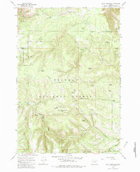
1967 Map of Bally Mountain
USGS Topo · Published 1983About this map
Bally Mountain rises as a central landmark within this 1967 survey of the high country spanning the Umatilla and Union County line. The landscape is defined by the intersection of the Whitman and Umatilla National Forest, with a significant portion dedicated to the Starkey Experimental Forest. This scientific and forestry-managed terrain is marked by essential high-country infrastructure, including Bally Camp and a Lookout Tower positioned for fire surveillance.
Find a feature on this map
45 named features on this map. Tap any name to fly to it.
Don’t see what you’re looking for? This feature index may not catch every label — zoom into the map to look around manually.
Map Details
Editions of this 1967 Bally Mountain Map
Other maps of this area

1953 · Pendleton
USGS Topo · 1:250,000

1956 · Pendleton
USGS Topo · 1:250,000

1963 · Meacham Lake
USGS Topo · 1:24,000

1964 · Mc Intyre Creek
USGS Topo · 1:24,000

1965 · Marley Creek
USGS Topo · 1:24,000
1967 · Bassey Creek
USGS Topo · 1:24,000

1967 · Sullivan Gulch
USGS Topo · 1:24,000

1967 · Lehman Springs
USGS Topo · 1:24,000

1967 · Bally Mountain
USGS Topo · 1:24,000
1967 · Sevenmile Creek
USGS Topo · 1:24,000