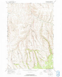
1969 Map of Balm Canyon
USGS Topo · Published 1973About this map
Rhea Creek winds through this section of Morrow County, where the high plateau is deeply incised by a complex system of drainage canyons. The northern portion of the map is defined by the Rhea Creek Cem and its namesake waterway, which receives flow from numerous side-canyons such as Graveyard Creek and Luncford Canyon. The landscape transitions into the Umatilla National Forest in the southeast, where the terrain rises toward Warm Hill.
Find a feature on this map
33 named features on this map. Tap any name to fly to it.
Don’t see what you’re looking for? This feature index may not catch every label — zoom into the map to look around manually.
Map Details
Editions of this 1969 Balm Canyon Map
2 editions found
Other maps of this area

1953 · Pendleton
USGS Topo · 1:250,000

1956 · Pendleton
USGS Topo · 1:250,000

1968 · Ruggs
USGS Topo · 1:24,000

1968 · Heppner
USGS Topo · 1:24,000

1968 · Skinners Fork
USGS Topo · 1:24,000

1969 · Summerfield Ridge
USGS Topo · 1:24,000

1969 · Chapin Creek
USGS Topo · 1:24,000

1969 · Madison Butte
USGS Topo · 1:24,000

1969 · Hardman
USGS Topo · 1:24,000

1969 · Big Rock Flat
USGS Topo · 1:24,000