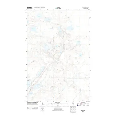
2013 Map of Balsam
USGS Topo · Published 2013About this map
Balsam is situated in a landscape defined by an intricate network of waterways and glacially formed lakes in central Minnesota. The hydrography of the region is notably complex, featuring the winding courses of the W Savanna River, E Savanna River, and the Prairie River. These streams connect numerous isolated water bodies such as Rat House Lake, Wolf Lake, and the expansive Big Sandy Lake in the southwest corner. The prevalence of named lakes, including Wakefield Lake and Shumway Lake, suggests a terrain shaped by heavy glaciation, providing a clear picture of the region's natural drainage patterns.
Find a feature on this map
29 named features on this map. Tap any name to fly to it.
Don’t see what you’re looking for? This feature index may not catch every label — zoom into the map to look around manually.
Map Details
Editions of this 2013 Balsam Map
This is the sole edition of this map. No revisions or reprints were ever made.
Other maps of this area

1953 · Duluth
USGS Topo · 1:250,000

1958 · Duluth
USGS Topo · 1:250,000

1969 · Island
USGS Topo · 1:24,000

1970 · Tamarack
USGS Topo · 1:24,000

1970 · Little Prairie Lake
USGS Topo · 1:24,000
1970 · Vanduse Lake
USGS Topo · 1:24,000

1970 · Balsam
USGS Topo · 1:24,000
1970 · Ball Bluff
USGS Topo · 1:24,000

1970 · Libby
USGS Topo · 1:24,000

1970 · Wright
USGS Topo · 1:24,000