
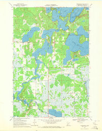
1970 Map of Tamarack
USGS Topo · Published 1972About this map
The Burlington Northern railroad cuts a straight line through the southern lowlands of this Aitkin County landscape, anchoring the small settlements of Tamarack and Grayling. This 1970 snapshot of the Northwoods reveals a complex wetland environment dominated by the Grayling State Wildlife Management Area and the Savanna State Forest. In the northern portion, prominent water bodies like Island Lake, Round Lake, and the eastern reaches of Minnewawa Lake are surrounded by dense forests and marshes, with the Savanna Portage State Park marking the upper boundary. For local researchers, the map provides precise locations for the Fairview Cem and several Gravel Pits, indicating the localized extractive activity alongside the preservation of wildlife habitats. The transition between the organized townships of Shamrock and Mc Gregor highlights the era's balance between rural homesteading and state-managed conservation.
Find a feature on this map
25 named features on this map. Tap any name to fly to it.
Don’t see what you’re looking for? This feature index may not catch every label — zoom into the map to look around manually.
Map Details
Editions of this 1970 Tamarack Map
This is the sole edition of this map. No revisions or reprints were ever made.
Other maps of this area

1953 · Duluth
USGS Topo · 1:250,000

1958 · Duluth
USGS Topo · 1:250,000

1969 · Automba
USGS Topo · 1:24,000

1969 · Lawler
USGS Topo · 1:24,000

1970 · Mc Gregor
USGS Topo · 1:24,000

1970 · Little Prairie Lake
USGS Topo · 1:24,000

1970 · Balsam
USGS Topo · 1:24,000

1970 · Libby
USGS Topo · 1:24,000

1970 · Wright
USGS Topo · 1:24,000
1970 · Minnewawa
USGS Topo · 1:24,000