
1969 Map of Lawler
USGS Topo · Published 1972About this map
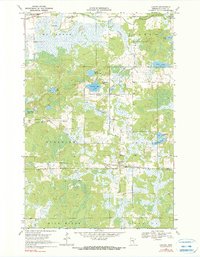
Lawler stands as a focal point in this 1969 survey of Aitkin County, centered on a landscape where wetland drainage and timber transport defined local development. The presence of the Soo Line and the Burlington Northern railroads, alongside an Old Railroad Grade, reflects an era of industrial logistics through the northern woods. The map reveals a community structured around shared faith and memory, marked by the Sheriff Lake Tabernacle and several local burial sites including Salo Cem and Grayling Cem. Hydrological features like the Sandy River and Sheriff Lake dominate the terrain, while the Lawler Lookout Tower suggests the ongoing importance of fire surveillance in this heavily wooded region during the late 1960s.
Find a feature on this map
30 named features on this map. Tap any name to fly to it.
Don’t see what you’re looking for? This feature index may not catch every label — zoom into the map to look around manually.
Map Details
Editions of this 1969 Lawler Map
2 editions found
Other maps of this area

1953 · Duluth
USGS Topo · 1:250,000

1958 · Duluth
USGS Topo · 1:250,000

1969 · Thor NE
USGS Topo · 1:24,000

1969 · Split Rock Lake
USGS Topo · 1:24,000

1969 · Ronald
USGS Topo · 1:24,000

1969 · Automba
USGS Topo · 1:24,000

1970 · Mc Gregor
USGS Topo · 1:24,000

1970 · Tamarack
USGS Topo · 1:24,000

1970 · Wright
USGS Topo · 1:24,000
1970 · Minnewawa
USGS Topo · 1:24,000